Snowshoe Backpack + Bushwhack
Salmon-Huckleberry Wilderness, Oregon
My friend Jen (UpGirl Outdoor Adventures) and I had been talking on and off for a couple months about a winter overnight trip to Devil’s Peak, a rugged prominence on a mostly-forested ridgeline in the Salmon-Huckleberry Wilderness where an old fire lookout still stands. Jen had received a sample of a new Gregory backpack to write a gear review and was ready to test it out in the wild. We made our plan for March 20-21, which – serendipitously – was the last day of winter and the first day of spring. We intended to start at Green Canyon Trailhead, snowshoe up with our gear, and stay the night at the fire lookout before descending the next morning around the east side of the mountain to complete a ~16 mile loop.


The Plan
Our original ~16mi loop hike plan – which we ended up changing mid-trip – was the following: (Day 1) Green Canyon Trailhead --> Devil's Peak, (Day 2) Devil's Peak --> Kinzel Lake --> Salmon River Trail --> Green Canyon Trailhead.
After an amazing but incredibly challenging first day of snowshoeing, we assessed our options and ultimately decided to change our plan to return the way we came for a ~14-mile out-and-back: (Day 1) Green Canyon Trailhead --> Devil's Peak, (Day 2) Devil's Peak --> Green canyon Trailhead.
I had completed the ~16mi loop hike a few times before: once as a dry, 2-day hike with a surprise snowfall on day 2, once as a 1-day trail run with warm, dry weather, and most recently as a 2-day hike in November in cold rain. Each of these experiences were beautiful, challenging, and rewarding in their own ways. I anticipated the snowshoe with Jen to be all of the above, but to also be more difficult due to the snowy conditions. That was indeed the case – but the snowshoeing conditions we encountered offered a higher level of physical and mental challenge and learning than either of us anticipated. It was the right decision to switch up our plans for Day 2 so we could enjoy the trail and feel more comfortable with the snowy descent.
Trip overview
Activity Snowshoeing / Backpacking
Location Salmon-Huckleberry Wilderness, Oregon
Ecosystem Types Lowland temperate rainforest, fir-hemlock
Start Green Canyon Trailhead
Finish Green Canyon Trailhead
Duration 2 days
Total Mileage 14.0
Lowest Elevation ~1,600’
Highest Elevation ~5,045’
Total Gain/Loss ~5,000’
Season Winter
Trail Tread Bare ground for the first 2 miles, snow for the rest. 3-5’ of snow at the summit.

Day 1

Jen hiking up the Green Canyon trail
Green Canyon Trailhead to Devil's Peak
Jen, her dog Sebastian, and I started up Green Canyon Trail in high spirits, sun, and warmth. We began without snowshoes, since the first part of the trail was bare ground. I was elated to be outside on such a beautifully warm day and catch up with Jen about life in such a beautiful, spring-like forest.
After a couple miles of climbing, snow patches began appearing on the trail. We had to traverse one particularly steep section that made me feel quite nervous, as the land below the trail was exposed and very steep. It required immense concentration and deep breathing to stay strong, slow, and careful with each step. I was relieved when we'd crossed that section, but was also concerned about hitting a section that could be more challenging higher up the trail.
We topped out at a ridge, checked the map, and turned left toward the junction with Hunchback ridge, which runs perpendicular to the ridge we were on. Once we were on Hunchback ridge, we just had to follow the ridge southeast then east to top out at the ridge’s summit. I remember feeling relieved to have reached Hunchback Ridge after the tough climb up Green Canyon, but also a little uneasy that it had taken us quite a bit longer than we thought. Snow-going was definitely slow-going!
Once we reached deeper snowpack on the higher ridges, the trail wasn’t distinguishable from the rest of the forest, as it was buried under 2, 3, sometimes 4 feet of snow. I’d brought my compass and a topographical map of the area to do some wayfinding thinking that there would be areas of unfamiliarity with the snowpack, despite my familiarity with the area. We also had GaiaGPS on our phones to check up on our location and make sure where we thought we were on the physical map matched up with reality. There were a couple sets of footprints that roughly followed the trail, perhaps from other weekenders, but I didn't want to rely on them. There were times where they could've mislead us, had we relied on them entirely.

My map and compass
On the first part of the ridge, we were still wearing just shoes and microspikes, since the snow was dense and our total weight wasn’t heavy enough to posthole. We put our snowshoes on when we started to sink through the snow up to our thighs after crossing over some small downed trees. Even when we didn’t need snowshoes to “float”, they proved to be excellent for traction on the steep terrain on the next part of the ridge climb.

Nearing sunset on the ridge
This is where navigation became more difficult, especially when we started losing some daylight. When following a bearing, we’d sometimes need to weave around or backtrack a short distance to find an alternate way around a steep ridge, a rocky outcropping, or a tight clump of rhododendron. At one point, we checked the map and saw that the actual trail ran around the right side of a prominence on the ridge, but after assessing the steepness of the slope, we decided instead to backtrack and bushwhack up the other side of the prominence to see if there was a better way around. It took some time and patience to find, but indeed, there was a better way.

Nectarine glow – the last light on the last day of winter

Sunset on the high ridge
We were probably at around mile 6, with about ~1+ miles still to go. We were feeling tired, but the sunset on the ridge was absolutely astounding and invigorated us for the final push. We took a moment to enjoy the nectarine light... and then, onward, with the impending dark beginning to bear down on our minds.
We discussed bivvy options in case we needed to stop for any reason, but the weather was excellent – relatively mild, cloud-free, and not even a breeze. With the pattern, conditions were expected to stay excellent into tomorrow. We were in fine shape, although navigating at twilight on a 5,000' ridge in 4' of snow certainly kept us alert, attentive, focused, and ultimately exhausted us.
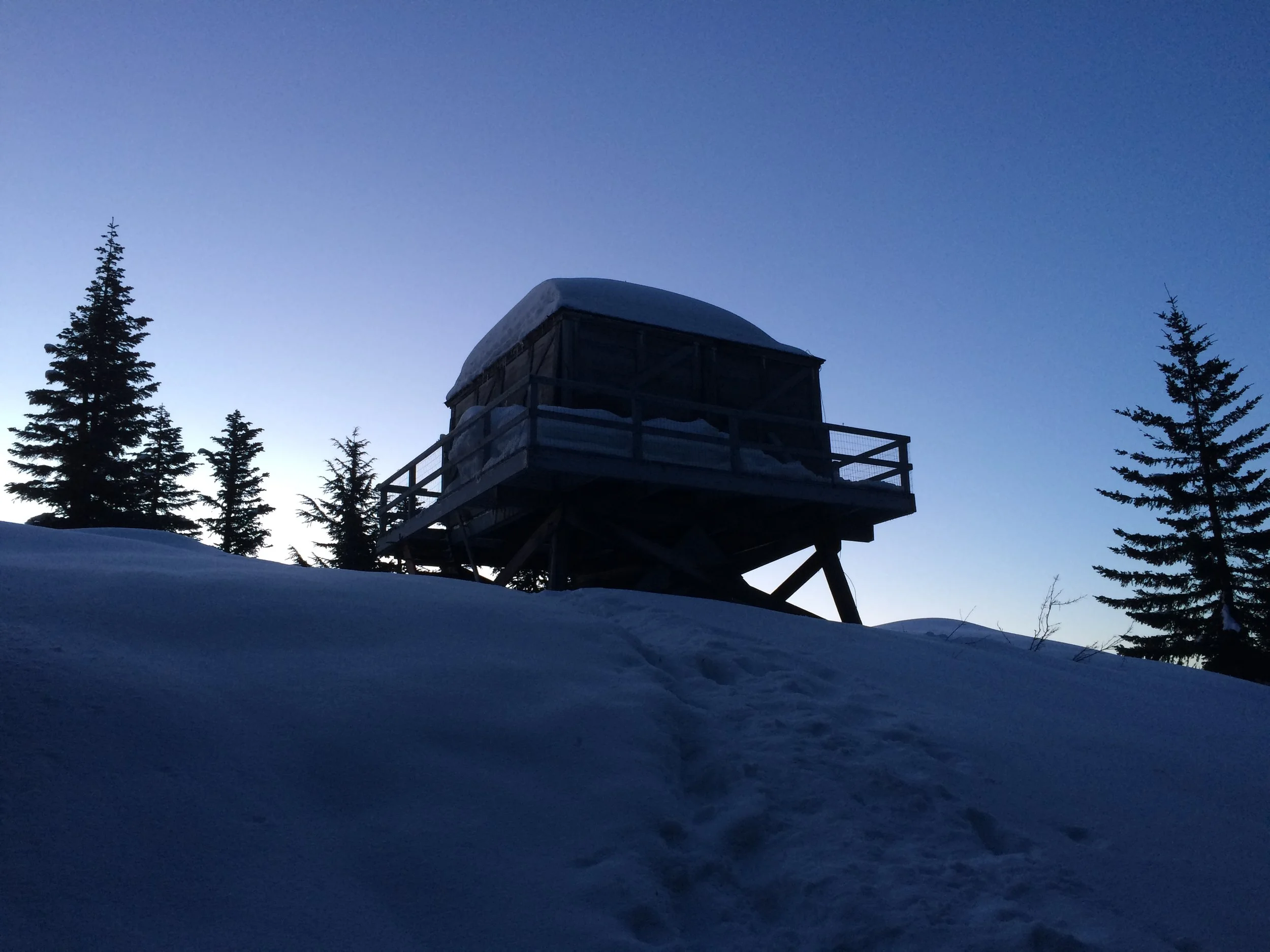
After five hours of nearly non-stop climbing, the last 45 minutes of it in the dark, the fire lookout was a welcoming sight! Joyous hugs and tail-wagging aplenty at that long-awaited moment!

We reached the lookout tower about 45 minutes after sundown
The inside of the tower was as rustic and as charming as always, a luscious relief after our exhausting day. I tried to start a little fire in the woodstove and got it lit, but couldn’t keep it going as the wood was wet with snowmelt. Although we couldn't be super toasty with a fire, it definitely wasn't too cold inside – temperatures dipped down to the low 20s at the lowest that night, and the shelter provided excellent protection from the breeze. More important than searching for dry wood was to eat a warm meal together, relax our exhausted legs, and enjoy the comforts of toasty sleeping bags (and a toasty Sebastian).
That night, we discussed our options for the return trip. We were leaning toward changing our original plan of completing the loop, so we could instead return the way we came. This would avoid the unknown of what was to come if we were to continue the loop around the mountain in terms of steepness, exposure, and wayfinding. Immediately, I felt relieved about the decision to backtrack, but was worried about a couple sections in particular could potentially be much tricker descending than ascending.
But for the moment, I just had to try to sleep and not let my mind wander too deep into tomorrow’s descent.
day 2
Devil's Peak to Green Canyon Trailhead
My heart was pounding on and off throughout the night, working hard to supply tired muscles with oxygen-rich nourishment. With a mind awake much of the night from anxieties about the upcoming descent, it wasn't difficult to get out of my sleeping bag and watch the sunrise – especially when this is the view off the front porch.

Sunrise at Devil's Peak
We rustled around for a hot lentil breakfast at 6:45 and divided up some water for ourselves and for Sebastian. There's something magical about camping out in a lookout, especially after a 7 mile snowshoe/bushwhack with 5000' gain. At this particular tower, maintained by much-appreciated volunteers, there are all kinds of useful objects left behind by fellow hikers. Jen spotted some yaktraks in the tower and borrowed them for the descent. She mentioned that she'd like to return them next time she's up here, or bring up something else to leave in its place. There wasn't a trail register in the tower like usual, so I collected the scattered journal entries into a pile, added our own brief trail logs, and secured them in a prototype Trailbook I made. Perhaps another larger trail log will come along, but for now, this little one'll do!
We returned to discussion of our route for the day. Neither of us wanted to do more extended wayfinding in the snow, especially on as-of-yet uncharted territory on the back side of the mountain. The notion of continuing on with the loop, however, did have its merits: the descent was much less steep overall, and from experience on previous trips I remembered that it doesn’t have the same quality of “sketchy” as what we’d just hiked. But, I couldn't be sure – I'd never hiked that descent in winter before, and thought that the ridge around the back of the peak might end up being too exposed for comfort. Although I dreaded the steep descent down the way we'd come, I agreed with Jen that it’d be a wise choice to re-trace our tracks and return the way we came for less mileage, peace of mind, and a mental break from wayfinding. Those discussions were excellent reminders of the importance of flexibility to ever-changing circumstances while on the trail. There’s a difference between feeling relieved about a decision because you’re taking the easy way out, and feeling relieved about a decision because it’s a wise one. Sebastian the pup was ready for anything, so it felt good to make a decision that felt right for everyone.

Trailbook left behind at the lookout

Writing a note in the log
We locked up the lookout and started the descent. The snow had hardened up with the cold night temperatures, we'd had the chance to rest our minds and legs, and the descent was easier going. Once we made it past the section that had sketched Jen out the night before, our spirits lightened up. She realized that the section felt different in the daylight on the descent; it wasn't as mentally or physically taxing as it had been. Things were feeling good!
The descent on snowshoes was demanding, but I felt much lighter mentally and physically than the day before. I stayed present, but occasionally my dread of the "sketchy" traverse section of switchbacks 2 miles from the trailhead would sneak into my head. Once we arrived at the beginning of the traverse, I took a deep breath. Thankfully, just as Jen had felt on the section up by the lookout, this particular section didn't feel as daunting to me as they did the day before. Jen's confidence and positivity, as well as mustering up some of my own, helped calm any lingering anxiety immensely. The traverse still required a steady mind and crystal-clear focus... but then, it was done. We were home free!
Throughout the entire trip, we didn't see anyone else on the ridges except for a couple day hikers on the lower, snow-free section of the Green Canyon trail. We made it back to the car in just about five hours, about the same amount of time that it took us to ascend.
In Hindsight
This trip was incredibly inspiring and equally as challenging.
It taught me more about my own fear boundaries, and how/when it's appropriate to push them.
The trip also reminded me to exercise respect for the boundaries of others, as they may be different from our own.
There was a steep, slippery, exposed section on the switchbacks that made me fearful, but it didn’t sketch Jen out. And vice versa – there was a section near the summit where we had to traverse an angled slope that I felt okay snowshoeing on but that Jen was sketched out by in the dark. At that point, we reminded ourselves that we had full batteries in our headlamps (and extra headlamps), we had our navigation, and we were close to the tower (but even if we didn’t make it, we had all the gear we’d need to snow camp).
Once we vocalized our concerns and made the decision together to just take it slow and keep on looking out for each other, anxieties could subside and a sense of wonderment for the snowy woods at night could return.
Sebastian, throughout it all, was a boss. He's the ultimate snow trail dog and set an incredible example of how to be fully present, to be honest about how you're feeling – and of course, to enjoy yourself out there in the woods!

Jen and her dog Sebastian all geared up and ready to hit the trail
For this trip, I was expecting there to be deep snow with the probability of no easy trail to follow. I knew we’d need to do some bushwhacking and navigation. But I did not expect there to be as much navigation as was ultimately required, and neither of us anticipated that it’d take us until after sundown to reach the fire lookout.
We began our hike at Green Canyon a little later than we’d hoped, and even with the blessings of Daylight Saving, we couldn’t quite eke out the summit before dark. Additionally, our extended time on Hunchback Ridge was due to the sustained and extreme steepness of the terrain on snowshoes, which meant that we simply had to move slower than we usually would.
Each trip will have its unexpected challenges, so preparedness for the unexpected – especially in winter, with extreme weather, and remote places – is a must.
While our pace was slow overall, it became much slower when we had to take our time in places that I’d define as “sketchy”, meaning that we had to literally watch every step and be "on it" mentally at every moment. There were several sections – some up to a few tenths of a mile – where the snow was piled up on the side of the ridge at a steep angle that continued down, down, down, to…. somewhere far below. As long as we stayed focused on the task underfoot, made certain that each step was planted securely into cut-out steps in the snow, leaned in slightly toward the up-facing slope, and stayed strong, smooth, and slow in our legs, we could cross these tricky sections safely. If we started to over-think the challenge of the situation and let our tiredness take over, we’d be more prone to making mistakes.
I wouldn't necessarily want to step into that pretty-far-out-of-my-comfort zone again, but I don't regret doing it for this trip.

Our GPS track on the Hunchback Trail (yellow) compared to the actual trail route (red) mapped out after the trip CalTopo
My GPS watch clocked 6.99 miles for the ascent and 7.00 miles for the descent. It’s interesting to note how these numbers differ from the trail mileage on my Mount Hood Wilderness map, which says that Green Canyon to Devil’s Peak is 5.3 miles from the trailhead. This is a 1.7 mile discrepancy, some of which can be attributed to our natural meandering off the trail as we were bushwhacking and following a compass bearing. I might also attribute the discrepancy to the GPS watch itself, which may have added additional mileage. It’s also possible too, of course, that my trusty map has some inaccuracies (but I would hope not!).
The route required a lot of us, mentally and physically. I would not recommend this hike in winter for navigationally inexperienced hikers who aren't in excellent physical condition.
Jen and I felt inspired as well as challenged by the experience and have so much gratitude for our physical condition and mental strength that allowed us to get up and down safely, and – for the most part – enjoy the journey! Jen's sample Gregory Octal 45L proved to be a good pack for a short winter trek like this. Check out Jen's review of the pack here. An immense thank you to Jen and Sebastian for your positivity, strength, and steady spirits in this long-awaited adventure.
– Sprout